Whitewater Rafting on California's Cherry Creek
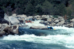 Cherry Creek is an experts only run rated Class V+. With
an overall gradient of 110 feet per mile and a "Miracle Mile"
dropping at over 200 feet per mile, Cherry Creek is possibly the most challenging
whitewater rafting run in the nation.
Cherry Creek is an experts only run rated Class V+. With
an overall gradient of 110 feet per mile and a "Miracle Mile"
dropping at over 200 feet per mile, Cherry Creek is possibly the most challenging
whitewater rafting run in the nation.
Once the winter snowpack has finished melting and spring rivers run short on water, river flows suitable for whitewater rafting allow Cherry Creek to run as late as October. Whitewater rafting permits and camping are available through the Stanislaus National Forest Service. The mile-by-mile & river descriptions found in this website cannot replace the judgment and skills required to guide this river. The shuttles and access directions are fairly easy but the shuttle is long and slow going.
General Whitewater Rafting Information
- Put-In: Cherry Creek just below the bridge.
- Difficulty: Class V+
- Length: 9 miles
- Season: March - mid-May (before snowmelt) or July - October (after snowmelt)
- Gradient: 110 feet per mile overall
- Runnable Levels: 600 to 2000 cfs
- Special Hazards: 1 portage around Lumsden Falls mile 7
- Take-out: Meral's Pool